
TOLEDO, Ohio — March weather can be a wild card, delivering everything from spring warmth to heavy snowfall.
This month has started off with numerous ups and downs in the weather department, and will continue to bring erratic weather across the board. Friday's heavy snow and cold breeze are reminders that winter weather isn't done, and the WTOL 11 Weather Team has issued an Alert Day for the travel impacts associated with this storm system.
In this week's Climate Friday, the WTOL 11 Weather Team will analyze the frequency of late-season snowfall and look ahead to what the rest of March may have in store along with signs of spring you can look forward to.
Ohio and Michigan are no strangers to March snowfall, and the month normally brings 5.3 inches of accumulation. Late-season snowfall is quite common, and sticking snow occurs almost every March.

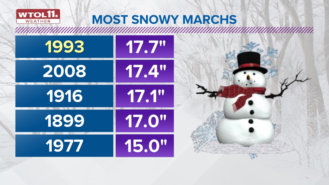
When you think of spring, you likely picture rainy weather and umbrella season, but snowfall still strikes late in the year. Some historically snowy Marches have dosed out over a foot of accumulation. Topping the list as the snowiest March on record is 1993, which brought a whopping 17.7 inches of snowfall. Another snowy March in more recent memory happened in 2008, which dosed out 17.4 inches of accumulation.
While today's Alert Day storm system won't bring snowfall totals close to these unseasonable years, it will serve as a reminder that winter isn't over just yet. Beyond March, April brings an average of 1.3 inches of accumulation. May features the occasional snow flurry or two, but does not bring any accumulation on average.
In total, the spring season brings an average of 6.6 inches of snowfall, a reminder that we're not free from wintry weather until at least May.
Even with the occasional burst of March snow, the month brings an abundance of rainfall as well. March typically brings 2.6 inches of rain, but some years far exceed that average. The wettest March on record is 1913, which brought an impressive 7.99 inches.
We'll likely see a mix of rain and snow this month as Mother Nature transitions from winter to spring.
So how is climate change impacting spring precipitation, and what trends will become more likely in the future? Rainfall is growing more intense and frequent due to global warming, and the causal link between increased temperatures and more moisture explains the uptick in spring rainfall.
Precipitation rate has increased by over 25% since 1970, and this graph shows the increasing trend in rainfall intensity, measured in hundredths of an inch in this case.

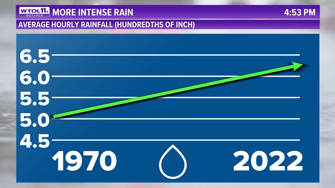
Heavier precipitation will occur more regularly in a world with warmer temperatures, and the more the mercury climbs, the steadier rainfall will become. The recent stretch of wet weather exemplifies this broader trend: our February rainfall of 4.93 inches reflects a big shift toward wetter weather.
While climate change is making precipitation more intense and frequent, weather patterns are also responsible for the day-to-day fluctuations in the weather. Seasonal weather patterns like La Niña help explain the wet weather that has been commonplace this winter. During La Niña winters, wet weather is prevalent across the Great Lakes, from the Ohio River Valley to the Upper Midwest.
On a more day-to-day level, shifts in the jet stream are responsible for weekly weather patterns that determine individual storm systems and precipitation trends. While climate change is just one of several factors impacting spring precipitation, it also impacts other aspects of seasonal weather.
Climate change is increasing the length of the growing season, in turn exacerbating spring allergies. Because milder days and nights are more common, spring allergens can proliferate and cause more irritation for a longer period of time.
Time will tell how this allergy season pans out, but it is statistically likely to be a severe one due to the prolonged stretch of mild conditions.
We've talked about spring snowfall and other reminders of winter, but what about some signs of spring? Now that March is well underway, we can look forward to signs of brighter, milder days ahead.

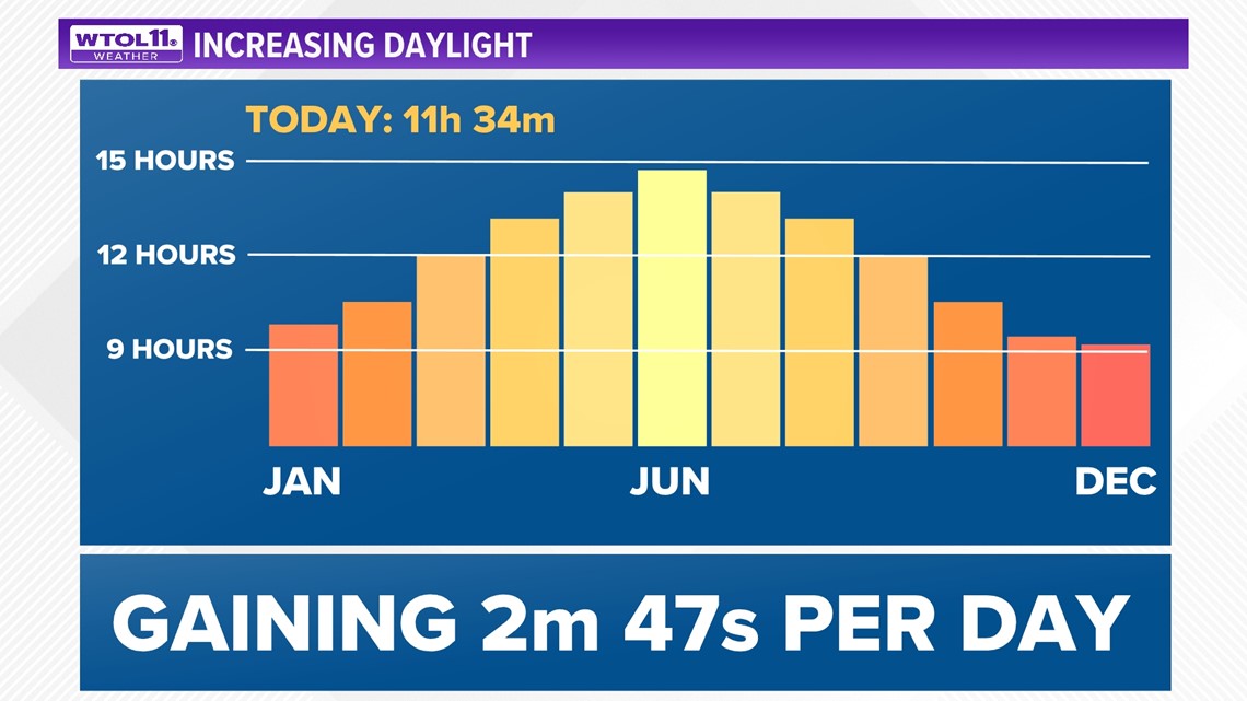
This weekend we'll "spring forward" an hour early Sunday morning as daylight saving time begins. After the time change, sunset time will shift back to 7:37 p.m. and you'll enjoy a sliver of daylight until 8 p.m.
Spring daylight will grow exponentially longer as March unfolds, and we're currently gaining 2 minutes, 47 seconds per day. By the end of the month, sunset time will be at 7:58 p.m. with daylight extending until 8:26 p.m.
Though March is a meteorological wild card that brings extreme weather on all ends of the spectrum, spring weather will be here before you know it. Stay tuned to the WTOL 11 Weather Team for updates on whatever the March season has in store.
RELATED VIDEO