
TOLEDO, Ohio — After a historically dry May and early June, recent rainfall has helped alleviate drought conditions in northwest Ohio.
In this week's edition of Climate Friday, we'll recap where we stand on rainfall and how climate change is affecting precipitation and worsening drought.
A week ago, Toledo hadn't received a drop of rain all month. After the driest May since the Dust Bowl era in the 1930s, June started off rain-free for 10 days.
Now, June rainfall is up to 0.88 inches, still far below-average, but at least an improvement. Monthly rainfall is still almost two-thirds of an inch below normal, and area farmers and gardeners could use a bit more rain.


With 0.38 inches of rain on Sunday, another half inch on Tuesday, and more rain Thursday, the Great Lakes region has finally enjoyed the impacts of several storm systems. Recent rainfall has largely depended on geographical region, and areas southeast of Toledo have received more rain while locations northwest have seen a bit less.
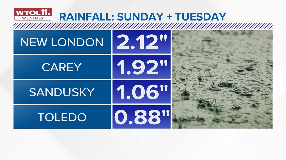
Locations like New London and Carey have picked two inches of rain or more. Other spots like Sandusky and Toledo have seen closer to an inch.
These rainfall numbers pale in comparison to the extreme rainfall amounts across central and northeast Ohio. Areas west of Columbus and northeast of Dayton picked up 4-6 inches of rain.
Slow-moving downpours and thunderstorms on Sunday dropped persistent and heavy rainfall amounts. While most of the region desperately needed some rainfall, excessive downpours on dry soil can cause flooding. Too much of a good thing has concerns of its own.

The 1-2 inches northwest Ohio and southeast Michigan received provided needed moisture for farm fields and gardens without causing any flooding issues. Despite this recent beneficial rainfall, area farmers still need more rain, and we're 0.65 inches below normal for the month.
You will see a few more rainfall chances in the WTOL 11 10-day forecast.
So how is climate change impacting rainfall and precipitation patterns? Rising temperatures and global warming are affecting precipitation, in part due to greater evaporation.
When the weather gets hotter, more moisture is absorbed from the ground. This increase in evaporation dries out the soil and predisposes the ground to drought conditions.
As the world grows warmer, evaporation will continue to increase, thus drying out the ground even more. Furthermore, greater extremes in precipitation patterns are growing more commonplace.
In other words, when it rains, it pours. And when it's dry, it's really dry. This week's weather provided a case study in these precipitation extremes.
The WTOL 11 10-day forecast features periodic rain chances but also a good deal of sunshine. This even distribution of rain and sun provides farm fields the opportunity to absorb moisture and soak up the rain.
This more balanced weather pattern will likely continue into the latter half of June, and you'll see more rainfall after a historically dry May and early June.
RELATED VIDEO