
TOLEDO, Ohio — Severe weather struck the Great Lakes region earlier this week, dosing out strong winds, heavy rain, and numerous tornadoes.
Twisters touched down in northern Illinois and western Michigan, just missing Hillsdale County. This severe weather outbreak followed an active stretch of July weather that dosed out numerous storm systems. The WTOL 11 weather team is forecasting additional storm chances into the weekend and beyond, some of which may become strong to severe.
How is climate change impacting thunderstorm frequency and intensity? Read on for more.
First off, let's recap this week's severe weather and how it impacted northwest Ohio and southeast Michigan. Though the area saw heavy rain and frequent lightning, it's the tornado warning in Hillsdale County that really stood out.
Issued at 11:45 p.m., this warning was radar-indicated, meaning rotation on doppler radar suggested tornado potential. Despite the ominous radar signature, no tornadoes or damage were reported in Hillsdale County.
Areas west of Hillsdale weren't so lucky. In Colon, Mich., located approximately 30 miles west of Hillsdale, an EF-1 tornado touched down Wednesday evening. With wind speeds estimated at 90 mph, this twister damaged structures and lofted debris up to 200 yards in the distance.

The tornado touched down almost directly overhead a storage facility, damaging garage doors, roof decking, and metal covering. Though this powerful storm trekked into Hillsdale County, it did not produce a tornado or cause meaningful damage.
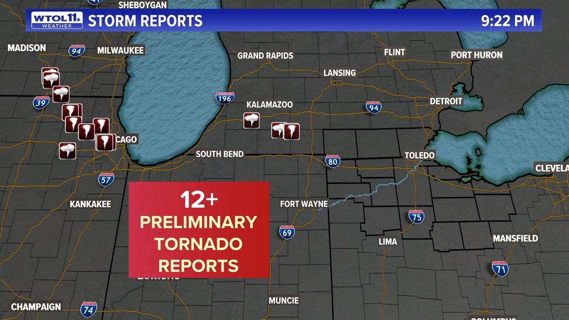
Though this storm cell hit close to home, stronger storms and numerous tornadoes touched down in northern Illinois, including the Chicago metro. The National Weather Service office in Chicago confirmed at least seven tornadoes in the area, some of which boasted wind speeds over 110 mph.
Several tornadoes touched down west of the city near locations like Summit and Cicero. Further storm surveys conducted by the National Weather Service will shed light on the intensity and scope of other tornadoes.
This severe weather outbreak represents just one of several this July, a month that has delivered active severe weather on numerous occasions.
So how is climate change impacting severe weather and tornado outbreaks? Hotter temperatures resulting from global warming have led to more evaporation and fuel for storms. With more moisture and heat to work with, storms are growing more intense and potent.
Rising warm air not only provides storms with water to dump out heavy rain, but also provides rising, warm air that strengthens thunderstorm updrafts and increases storm severity. Storm energy is growing across much of the nation, and the entire eastern United States has seen elevated thunderstorm potential based on data since 1979.

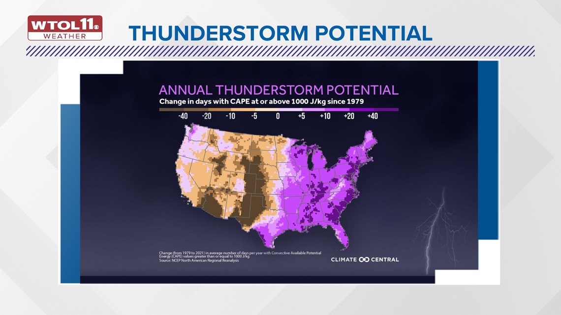
The purple color on this map shows increased thunderstorm energy, measured in units of Joules per kilogram of air. Though climate change has increased storm potential in the eastern U.S., these effects have not been ubiquitous across the country.
Much of the western U.S. and even portions of the traditional Tornado Alley in the Great Plains have seen a decrease in storm energy. Part of this may have to do with the increased prevalence of western drought.
Despite these inconsistent impacts, Ohio and Michigan have seen an overwhelming increase in storm energy over the past half-century. Even though the link between climate change and instability is clear-cut, the relationship with wind shear, or turning in the atmosphere, is more ambiguous.
Wind shear depends on a number of factors, including the strength of a low-pressure storm system and the intensity of the jet stream. It's impossible to pinpoint tangible impacts of climate change on wind shear, as each weather scenario unfolds differently based on unique variables in the atmosphere.
With these ingredients combined, tornado outbreaks have grown more intense, with an overall uptick in the number of twisters per system has grown markedly since 1950. Despite year-to-year variability, this graph shows the overall upward trajectory in tornado outbreaks, a trend that will continue in the future.
Mother Nature has dosed out stormy weather this month, and the second half of July will likely feature frequent thunderstorms. Whatever the weather, you can trust the WTOL 11 weather team for the latest information.
RELATED VIDEO