

TOLEDO, Ohio — When it rains, it pours.
Heavy downpours impacted the region this week as an active storm track delivered several rounds of rain and thunder. Rainfall totals over three inches fell in parts of Ohio and Michigan and flash flooding impacted cities across the Midwest.
Torrential rain is growing more common and intense, and climate change is playing a role. In this week's edition of Climate Friday, we will analyze the impacts of climate change on heavy rainfall and discuss the mechanisms behind it.
Though this weekend's storm systems only dropped about half an inch of rain at Toledo Express Airport where official weather observations are taken, some spots saw several inches and experienced localized flooding.
Areas southeast of the Maumee River felt the brunt of the storm systems. About three inches of rain fell near Walbridge and Clay Center, with up to 4.5 near the intersection of Lucas, Wood and Ottawa counties.

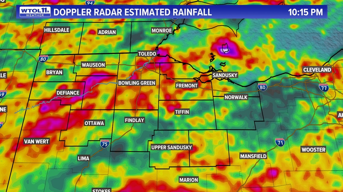
Rainfall totals varied greatly across Lucas County with heavier amounts to the south in areas like Waterville and lighter amounts to the north in locations such as Sylvania. Heavy downpours inundated western counties as well, leaving behind a swath of substantial rainfall right along U.S. 24.
Rainfall near Liberty Center, Napoleon and Ridgeville Corners amounted to around 3.5 inches. Defiance County also picked up three inches or more in spots.
Parts of Putnam and Hillsdale counties received rainfall amounts between two and three inches.
While much of the area has been under moderate drought conditions this summer, heavy rainfall still caused standing water and localized flooding. This recent rainfall is representative of a broader trend caused by climate change.
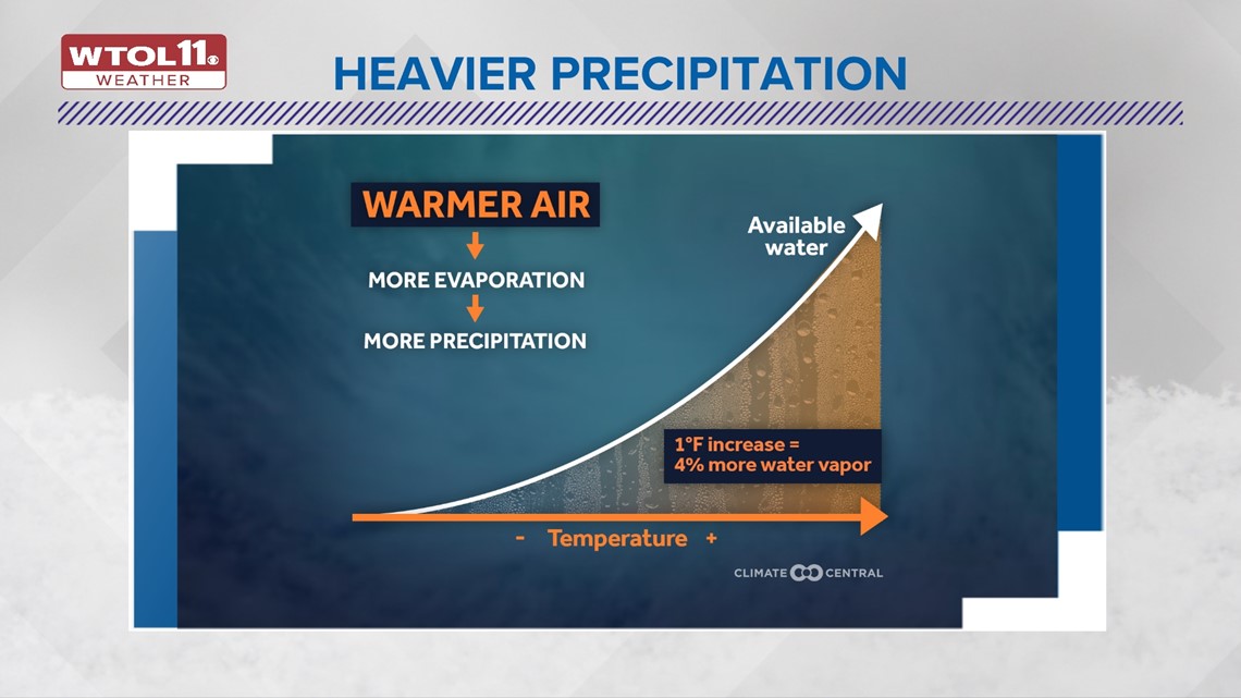
Climate change is making heavy downpours more common and intense. It's no secret that the world is getting warmer, and climbing temperatures have major ramifications on the water cycle.

With warmer temperatures comes increased evaporation from both bodies of water and the ground and soil. In other words, the heat saps more moisture from the ground, and evaporation provides clouds with fuel for rain.
As both air and water temperatures continue to climb, evaporation has reached unseen levels, fueling heavier rainfall and flooding. This mechanism continues to perpetuate heavy rain and increase the intensity of heavy downpours.
What about the real-world data on heavy rain and downpours? Studies over the last half century have show than 90% of cities across the country have observed an increase in rainfall. Not only is rainfall growing, it's increasing exponentially.
Midwestern cities have seen a vast uptick in precipitation totals. One study analyzed the change in annual precipitation since the 1950s.
Cincinnati has seen a massive 137% increase in rainfall during this time frame. Columbus observed a 78% rise in rainfall. Precipitation in Detroit rose 50% since the 50s.
And in Toledo, rainfall amounts increased 44%.

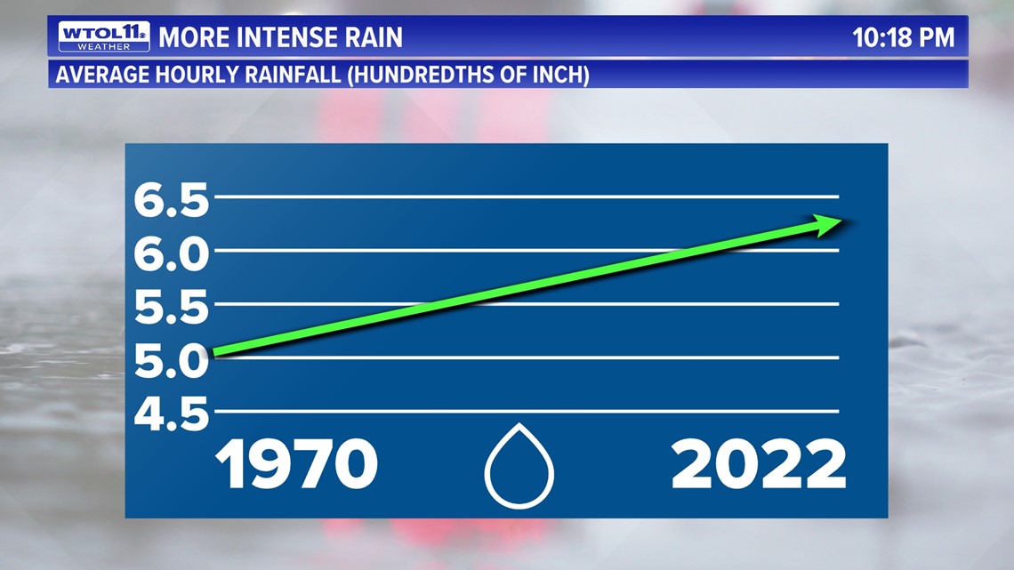
Not only is total precipitation growing, but rainfall intensity is increasing. Research on rainfall rates since the 1970s has shown a 25% or greater rise in rainfall rates during this time frame, a noticeable shift toward heavier downpours.
This combination of greater overall rain and heavier soaking downpours has elevated flooding risk across the country. Regionally, the Midwest and New England have seen the greatest rise in heavy rainfall.
Though the entire country has noticed an uptick in heavy precipitation events, the southwest and northwest have experienced the most subtle shift in rainfall. The Great Lakes region has seen a vast 42% rise in heavy rainfall events, defined as the top 1% anomalies that produce the most rainfall. This shift is largely due to climate change the the link between global warming and increased evaporation.
This trend toward heavy rain will continue in the future as temperatures continue to rise.
Though the active jet stream pattern will briefly subside this weekend, more rain and thunderstorms are in the forecast for early next week. The weather pattern through mid-July will feature cooler and wetter-than-normal conditions.
More heavy downpours will likely affect Ohio and Michigan, potential aggravating flooding concerns. Though some rainfall is necessary, too much of a good thing can cause more harm than good.
But with climate change, it seems that when it rains, it pours.
Whatever weather the rest of summer has in store, the WTOL 11 weather team will keep you safe and informed.
RELATED VIDEO