

TOLEDO, Ohio — This February will go down as the least snowy on record in Toledo. Without any snow accumulation, this month has looked and felt more like spring.
In this final Climate Friday of February, we will analyze the impacts of climate change on this historic snowfall deficit.
Unseasonable warmth has prevented widespread accumulating snow this winter, causing most of our precipitation to fall as rain. Liquid precipitation has been far more common than the frozen kind this month. February has brought consistently mild weather, the biggest culprit for the lack of snow.
With nine days over 50 degrees and three days in the 60s, this month has delivered spring-like warmth. With temperatures over 6 degrees warmer than normal, this month has featured anomalous warmth with temperatures largely above freezing.
Warm weather has impacted not only northwest Ohio and southeast Michigan, but much of the United States as well. Across the country, over 1,100 high temperature records have been set this month alone.
Looking at the past year, an incredible 37,000 high temperature records have been shattered across the country.

Climate change is making this unseasonable warmth more common, contributing to record temperatures and unusual warmth. Mild Februarys will grow more frequent in the future as this warming trend continues.
Snowfall has been hard to come by this month, largely due to frequent temperatures above freezing. So what does a normal February bring in the snowfall department? With 10.2 inches of snowfall, a typical February is the second snowiest month of the year, falling right behind January. A normal February features a mean temperature of 30 degrees, a far cry from the 40s, 50s, and even 60s that have been commonplace this month.
This February has brought zero accumulating snow, with only a few flakes and periods of wintry mix. The official weather reports taken at Toledo Express Airport haven't recorded any sticking snow all month.
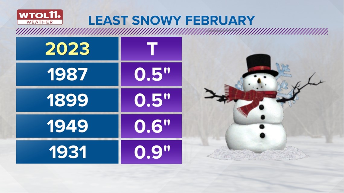
With just a trace of snowfall, this February will likely go down as the least snowy on record in Toledo history. Right now, 1987 and 1899 share that title, each of which only brought half an inch of accumulation.
This February will likely take the top spot when all is said and done, and the WTOL 11 weather team isn't forecasting any sticking snow for the next week.
This February has been a stark contrast to the last two, each of which delivered a major snowstorm with heavy accumulations. February 2021 was the seventh-snowiest on record, dosing out 22.7 inches of accumulation.
Last February ranked No. 11 in history, as 19.1 inches of snow fell. This February has been the polar opposite with no accumulation. What do each of these months have in common? They all occurred during La Niña winters.
This stark contrast in February snowfall goes to show that La Niña and El Niño aren't the only factors that impact winter precipitation. Even in today's era of climate change, snowy winters still can occur, but they are becoming less frequent.
If you're a snow-lover, you may enjoy reminiscing on some historic February snowfalls. The most snow for February in Toledo history, 2015, brought over two feet of accumulation, dropping 25.3 inches. Taking the second spot on the list is 2011 which brought 25.2 inches. This February will very likely end without any measurable snow.
Another impact of this very mild and snow-free February has been on Lake Erie ice cover. Ice on the Great Lakes normally reaches its peak in late-February through early March as winter temperatures bottom out and freezing reaches its maximum.

The Great Lakes are normally 45% covered by ice at the end of February. This year, ice cover is a mere 10%. This deficit in lake ice is a testament to the mild winter weather not only here at home, but across much of the region.
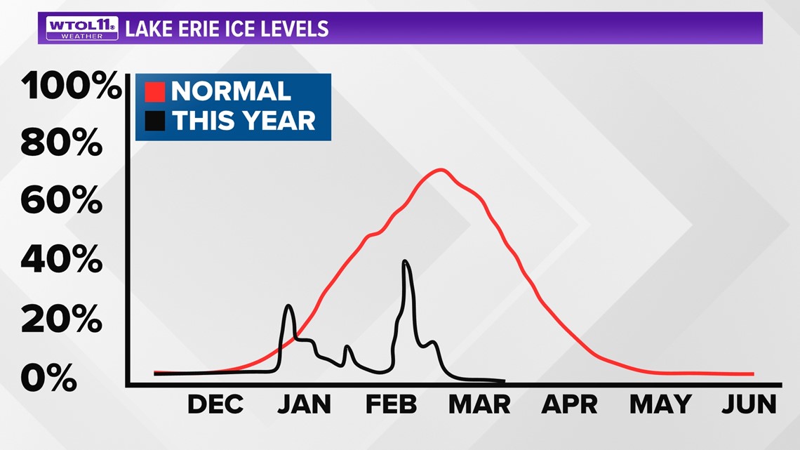
Where do we stand in terms of Lake Erie ice cover? Lake ice has diminished to nearly zero. Normally Lake Erie is over 60% covered. Despite brief spikes in lake ice after cold snaps at the end of December and January, all lingering icy spots have melted away this month due to the prolonged mild weather.
With a January 7.6 degrees warmer than average and a February 6 degrees above-average so far, the Great Lakes have thawed out. This mild trend without ice cover will likely continue into early March.
Though March and April can bring cold and snow, the long-range weather forecast remains mild for the foreseeable future.
RELATED VIDEO