TOLEDO, Ohio — With the holiday season right around the corner, the WTOL 11 weather team is keeping an eye on changes in the weather pattern that may bring our first taste of wintry weather. Sometimes, winter strikes early, dosing out heavy snow and bitter temperatures in November. Other years, winter weather doesn't arrive until well after the New Year.
In this week's edition of Climate Friday, Meteorologist John Burchfield breaks down our winter weather climatology and what you can expect this season.
November snowfall: When winter strikes early
Most years, November features the first taste of wintry weather. The first measurable snowfall of the season, defined as at least 0.1 inches of accumulation, typically occurs on Nov. 17. Even with the upcoming change in the weather pattern, the wet snowflakes that may fly next week will arrive later than average.
Our first inch of accumulation typically occurs on Nov. 29. As a whole, the month of November provides just a taste of wintry weather with an average of only 1.7 inches of accumulation. Last November brought a meager 0.2 inches of snowfall, and the year before featured 0.4 inches of accumulation. November, 2021 dealt more substantial snowfall amounts totaling 3.8 inches. November, 2020 delivered 1.3 inches of accumulation, closer to normal.

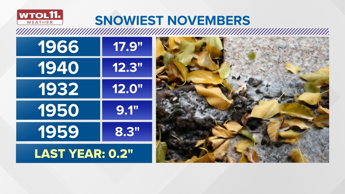
While most Novembers only bring a small amount of snow, winter can come early sometimes. November, 1966 holds the record with a whopping 17.9 inches of snowfall. This year was an extreme outlier, and most Novembers bring a much more miniscule amount of early season snow.
December: Big changes in the weather
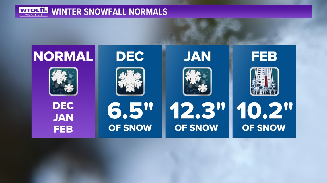
By December, snow and cold grow more commonplace. The winter season officially begins in late December, just a few days before Christmas. December is the third snowiest month of the year in Toledo, northwest Ohio and southeast Michigan with an average of 6.5 inches of snowfall.
Though many Midwesterners dream of a white Christmas, recent Decembers have been devoid of meaningful snowfall. Last December brought only a trace of accumulation with temperatures almost 9 degrees above average. December, 2023 included just 1.2 inches of snow accumulation and temperatures slightly above average.
Overall, December weather is growing milder and less snowy due to climate change. New climate data from the National Oceanic and Atmospheric Association (NOAA) reflects a 3.1 degree uptick in December temperatures in the past decade. December snowfall has decreased by nearly an inch in this same time period.

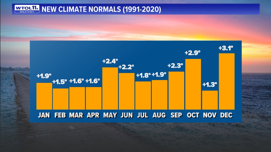
December has warmed up by more than any other month due to climate change. Because of this significant warming trend, the chances of a white Christmas have decreased over the years. Warmer temperatures often mean more liquid precipitation and less snowfall. As we round the corner from November into December, stay tuned to the WTOL 11 weather team for changes in the weather pattern that may impact our chances of December snowfall.
January: Snowiest month of the season
January is statistically the snowiest month of the year in northwest Ohio and southeast Michigan. With an average snowfall amount of 12.3 inches, January is notorious for dosing out the snowiest weather of the winter season, though not every year reaches that amount.
Last January brought only 8.1 inches of accumulation, approximately two thirds of a normal month. January, 2023 delivered only 7.9 inches of snow, also well below average. With monthly temperatures 7.6 degrees above average, this lack of snowfall is not surprising. January, 2022, while much colder than average, brought just 6.5 inches of accumulation.

Overall, the last three Januarys have failed to deliver the usual heavier snowfall common after the New Year. While it may intuitively seem like we're "due for one", Mother Nature knows no reciprocity, and the lack of recent snowfall does not guarantee a snowy January. The recent January snowfall deficit fits the framework of climate change, pointing toward a warmer and drier winter climate in the Midwest.
February: Trend toward backloaded winters
Finally, February wraps up the winter season with a wild card of weather patterns. Statistically, February is the second snowiest month of the winter with an average of 10.2 inches of snowfall. February can bring weather conditions ranging from major snowstorms to spring warmth.
Though the second month of the year typically doses out frequent snowfall, last February brought just half an inch of accumulation with temperatures 8.8 degrees above average. The year prior brought similarly mild and snow-free conditions with less than an inch of accumulation and temperatures 6.2 degrees above average.
The two prior Februarys dosed out significant winter storms. February, 2022 featured 19.1 inches of snow accumulation with the bulk of that during a Feb. 2 and 3 winter storm. February, 2021 brought historic snowfall with 22.7 inches of accumulation total, with a significant snowstorm dumping 14.5 inches of accumulation split between Feb. 15 and 16.

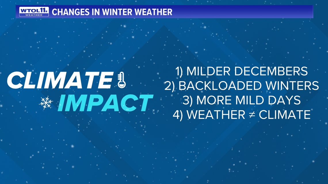
These recent February snowstorms point toward a shift to backloaded winters. While the first half of winter is turning milder and less snowy, February can often bring heavy late season snowfall. While some Februarys are devoid of wintry weather altogether, including 2024 and 2023, others can bring sizeable snowfall. Though February is still statistically the second snowiest month of the year, it may trend toward becoming the snowiest month if this backloaded winter trend continues.
Historic winter snowfall (or lack thereof)
Last winter failed to deliver any meaningful snowfall over the course of the entire season, taking the title of the least snowy winter season on record. With just 9.6 inches of snowfall, the winter of 2023-2024 was 27.4 inches below average in the snowfall department.
The second least snowy winter on record is 1918-1919 with 12.4 inches of accumulation. Ranking third is 1982-1983 with 12.5 inches. Fourth on the list is 1948-1949. And the fifth least snowy winter on record is 2022-2023 with just 14.3 inches of snowfall. The snowfall deficit in the past two winters represents a shift toward a less snowy climate, on average.

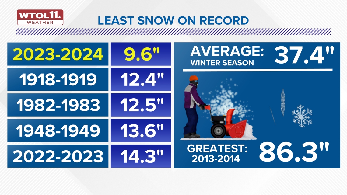
Despite this trend, statistical outliers can still dose out significant snowfall in today's era of global warming. The winter of 2013-2014 is one that slow-lovers will always remember for its historic 86.3 inches of snow accumulation. This record-setting winter delivered around nine times as much snow as last winter.
While it's unlikely a winter like this will occur again this season, snowy winters cannot be ruled out just because of climate change. Global weather patterns like El Niño and La Niña and weekly and daily shifts in the jet stream and weather pattern often play a bigger role in winter weather that the broader warming trend that scientists have observed across the globe.
So what can you expect this winter?
The WTOL 11 weather team is putting the finishing touches on the winter weather outlook and will break down the trends that may impact our weather pattern in the coming weeks and months. Even though this November started off milder and drier than average, a change in the weather pattern will bring cooler and wetter weather for the latter half of the month of November. Snow-lovers, listen up! This may include the first flakes of the season arriving by next weekend. Stay tuned to the WTOL 11 weather team for the latest 10 day forecast.

