TOLEDO, Ohio — As we prepare for the first significant cold snap of the season, that means not only grabbing the big winter jacket, but also the first large lake effect snow outbreak!
Lake-effect snow is one of the most striking features of winter in the Great Lakes region, delivering both beauty and chaos to the communities it affects. While Toledo is spared the worst impacts from lake effect snow it can still cause chaos travelling on regional interstates.
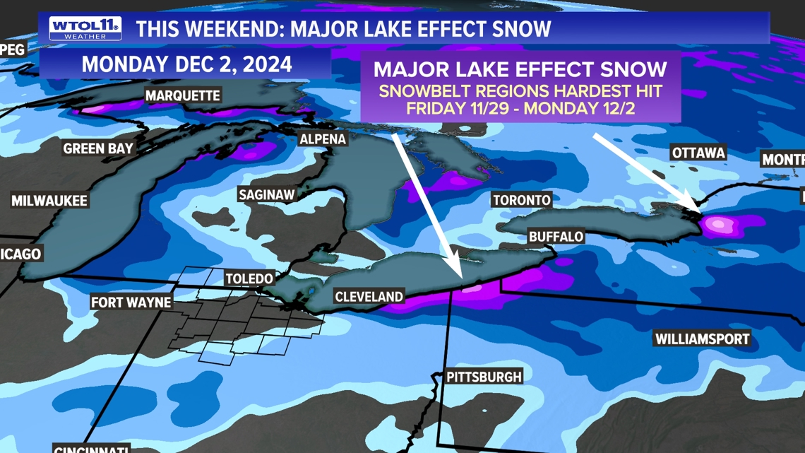
Over the Thanksgiving Day weekend it is likely the snow belt from Cleveland to Buffalo may record over 2 feet of snow. Due to the record setting warmth of the Great Lakes this very cold air will be the perfect combination for heavy and intense snow squalls. Heavy but less significant snow of several inches is likely in the snow belts of Michigan.


What causes lake-effect snow?
Lake-effect snow occurs when cold, dry air moves across the warmer waters of the Great Lakes, picking up heat and moisture. As this air rises and cools rapidly, it forms narrow but intense snow bands capable of dropping several inches of snow per hour. The snow is often localized, creating stark contrasts between areas buried under snow and those just a few miles away with barely a dusting.
The regions most impacted by lake effect snow are the eastern and southern shores of the Great Lakes, thanks to the prevailing westerly and northwesterly winds. These winds drive cold air across the lakes’ open waters, creating the perfect conditions for snow formation.
The distance the air travels across the lake, known as the fetch, plays a critical role. Longer fetches, such as those across Lake Erie or Lake Ontario, allow more moisture to be absorbed, leading to more intense snowfall. This is why areas like Buffalo, New York, and Erie, Pennsylvania, regularly experience massive snowfalls, often surpassing 100 inches annually.
Interestingly, the western shores of the lakes, including cities like Toledo, Chicago, Milwaukee, and Green Bay, rarely see heavy lake effect snow. The short fetches on this side of the lakes and the direction of prevailing winds prevent the necessary conditions from developing.
However, exceptions can occur. For example, easterly winds can push cold air over the lakes toward the west, occasionally bringing lake effect snow to areas not typically affected. These events, though, are often weaker and shorter-lived compared to the snowfalls on the eastern shores. This is due to the fact that east winds are often dry and not sustaining for long lasting or developing snow squalls.
Areas with significant lake-effect snow
- New York: Buffalo experienced a historic lake-effect event in November 2022, with some areas receiving over 81 inches in just a few days.
- Michigan: The Upper Peninsula averages up to 200 inches annually, with Munising often exceeding 230 inches in heavy snow years.
- Ohio: Cleveland’s lake effect contributes significantly to its 68-inch annual average, with higher totals in snowbelt suburbs.
For those living closer to these more favorable Great Lakes snowbelts, lake effect snow is both a challenge and a way of life. It can disrupt travel, strain infrastructure, and lead to sudden and severe winter storms.
Yet, these communities are well-prepared, using sophisticated weather models and robust snow management systems to cope. Lake effect snow remains a fascinating testament to the interplay of nature’s elements and a reminder of the power and unpredictability of winter weather.


