OHIO, USA — The WTOL 11 Weather team is forecasting a return to wintry weather on Friday with a possible snow-rain mix.
An ALERT Day has been issued for Friday, March 10, for the potential of more snow accumulation and a possible mix of rain.
We want you to be the FIRST to know the details our WTOL 11 Weather team can tell about this possible upcoming storm.
Here are the 3 Things to know about the WTOL 11 ALERT Day on Friday:
#1 | Timing
The storm system bringing our Friday snowfall is currently sitting just off the west coast, spilling rain and snow across northern California. With snow beginning in our area by early Friday morning, this system has a lot of ground to cover before reaching us. That’s why we’re expecting this threat for snow to be a swift one, lasting around 12 hours from start to finish.

The first flurries will begin just after midnight Friday morning and will gradually increase to a steady snow between 3 - 6 a.m. That steady snowfall will pick up during the morning commute and start winding down near or just after lunchtime. Rain showers may be possible, causing a wintry mix south of Toledo on Friday.
During this time, temperatures will hover near or just below freezing. Snow will have the best chance to accumulate on roads before sunrise, as the March sun angle is high enough to help road crews during daylight hours.
#2 | Accumulations
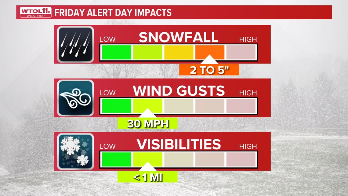
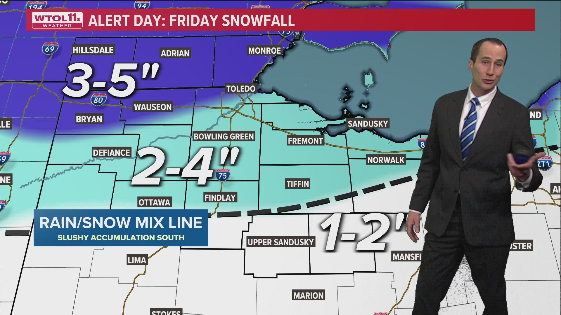
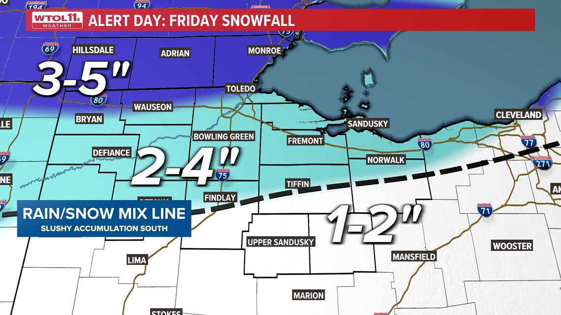
The heaviest one-day snow total in Toledo this year was 4.7 inches during a mid-January snowfall. This system does have the potential to rival that benchmark. Typically, a snow maker needs to get some moisture from the gulf of Mexico to produce that type of snow locally but this fast-moving system will bring a lot of Pacific Ocean moisture with it.


We must also keep in mind that March can be a tough time for snow to accumulate as quickly as earlier in the winter. Warmer ground temperature readings and high daytime sun angles will all work against snow piling up as high as it would during a colder month.
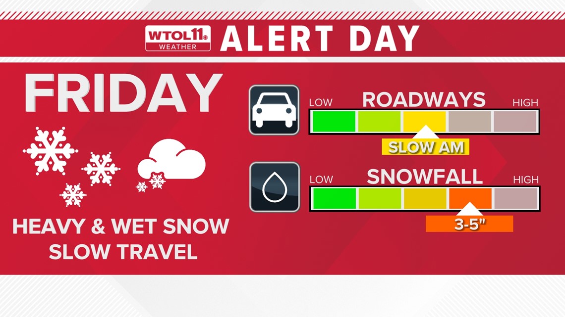
Right now, we expect most locations to receive around 2 - 4 inchesof an accumulation on the ground. Although more snow may fall from the sky, it will only add up to several inches on the ground due to the above mentioned issues.

#3 | Will it linger into the weekend?
Snowfall will begin to taper off by Friday afternoon and will end by Friday evening. The roads will take some time to be cleared as crews work to try and keep up with that accumulations Friday morning. We expect snowfall rates to reach around a half inch per hour Friday morning, which is the upper limit for plows to keep up with. These snowfall rates will dramatically drop by Friday afternoon and beyond.
Only a lingering light snow shower is possible into early Saturday morning, no more meaningful snow is expected. Temperatures will remain chilly Saturday, especially in the morning, which could allow for some patchy black ice to develop. Any weekend travel should not have any major slowdowns but secondary and lesser traveled roads may still have some patchy icy spots.