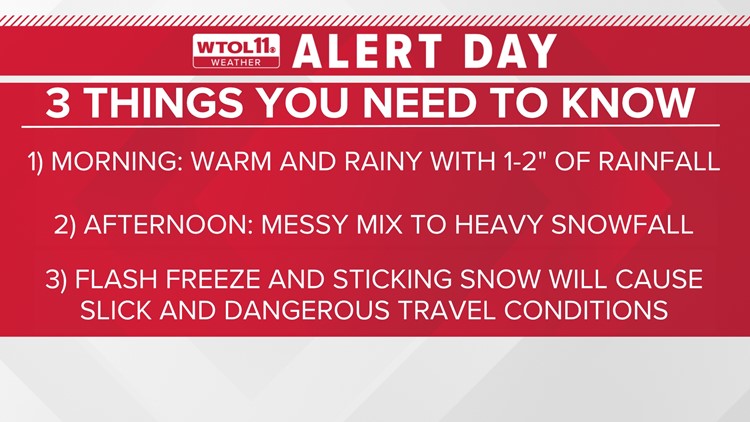
TOLEDO, Ohio — The WTOL 11 weather team has issued an Alert Day for Thursday as a dynamic storm system brings rain, ice, and snow to the region. Thursday morning will look and feel like spring with temperatures in the 50s and soaking rainfall. An inch or two of rain will cause elevated river levels, wet road conditions, and localized flooding. With plenty of rain on frozen ground, rivers could experience minor flooding and ice jams. Also, check your sump pump as basement flooding is also a concern.
Rain is expected to transition to a messy mix by lunchtime as temperatures plummet along a cold front. The further northwest you live, the sooner this changeover will occur. Southern Michigan may start to see an icy mix by 10 a.m., while the Toledo metro likely won’t switch over until around noon. A mix of rain, sleet and snow will cause slushy road conditions by the afternoon. By the evening commute, southeastern counties such as Crawford and Wyandot will begin to see a messy mix.
As cold air funnels in behind the cold front, heavy snow will fall Thursday evening, especially northwest of Toledo. Steady, wet snow will cause reduced visibility and slow travel for the evening commute. Steady snow will fall in northwestern suburbs like Sylvania, but the heaviest snow is most likely across southern Michigan. Snow will begin to fall after dark to the southeast of Toledo as temperatures fall. Widespread accumulations of 3-5” are likely, but isolated 5-7” are possible along and north of the state line.
As this dynamic storm system approaches, make sure to stay close to the WTOL 11 Weather app. The WTOL 11 Weather Team will have video updates, and the latest forecast straight to your phone.
More on WTOL 11: