
TOLEDO, Ohio — Summer marks the start of pool parties, and warmer weather, but it also marks the beginning of the annual hurricane season for many of the southern states and Atlantic islands and countries.
As we know living in our area, we are not directly impacted by tropical storms and hurricanes. But if you like to plan getaways out of the country or into the southern states during the summer months, going on vacation could be interrupted by these natural disasters throughout the summer months and sometimes in the heart of the fall season.
Most of the time when we hear about a named storm, it has already developed into the mature stage of a tropical storm or furthermore, a hurricane.
Have you ever wondered how a hurricane first develops?
For this week's WTOL 11 Weather Impact, we are breaking down the lifecycle of a hurricane.
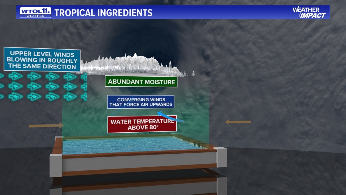
Like any other weather phenomenon, you need ingredients for a hurricane to form. Many different components and atmospheric traits must go into a hurricane forming. It also matters where it does form as well. Anywhere too cold will stop it from forming, but what a hurricane needs are the right ingredients to form to its full strength.
According to the National Oceanic & Atmospheric Association (NOAA) SciJinks, tropical cyclones are like engines that require warm, moist air as fuel. So, the first ingredient needed for a tropical cyclone is warm ocean water. That is why tropical cyclones form only in tropical regions where the ocean is at least 80 degrees Fahrenheit for at least the top 50 meters (about 165 feet) below the surface.
The second ingredient for a tropical cyclone is wind. In the case of hurricanes that form in the Atlantic Ocean, the wind blowing westward across the Atlantic from Africa provides the necessary ingredient. As the wind passes over the ocean's surface, water evaporates (turns into water vapor) and rises.
As it rises, the water vapor cools, and condenses back into large water droplets, forming large cumulonimbus clouds. These clouds are just the beginning. For this powerhouse of a system to form into a fully fledge hurricane it must go through two stages of becoming a tropical depression, eventually strengthening into a tropical storm.

Breaking down the difference between tropical depression, tropical storm, hurricane
Once a tropical system has all the ingredients made up it then forms into a tropical depression. At this stage, whether it is in the Atlantic Ocean or Pacific Ocean, the National Hurricane Center gives it a name.
Once it is an organized system, each level of strength is determined by the max sustained wind speeds of each system.
For example, a tropical depression's wind speed ranges from 38 mph or less. If this system were to strengthen by 1 mph or more, this would be categorized as a tropical storm where max sustained winds range from 39 to 73 mph.
If the system continues to grow stronger to where max sustained winds exceed 73 mph, this would be officially named a Category 1 hurricane, where surface max sustained winds reach 74 mph or higher.
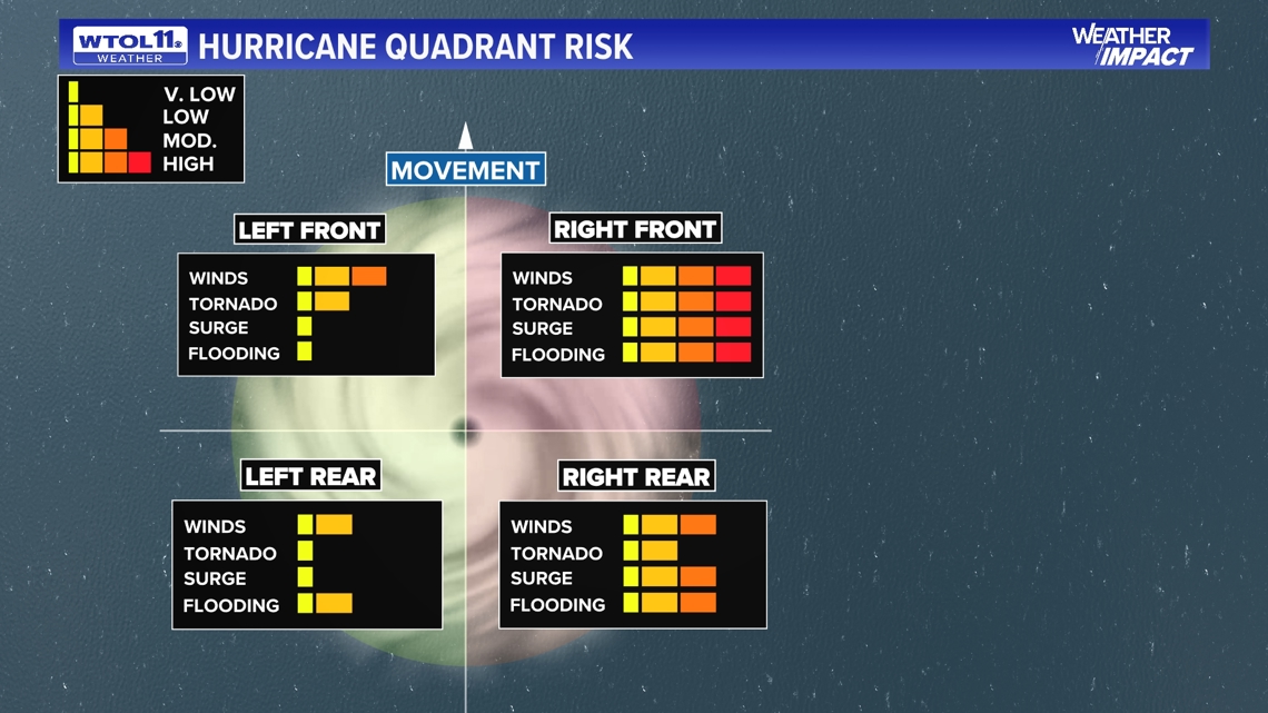
Quadrants of a hurricane
When talking about one of the largest weather events that occur across the world, hurricanes can be the size of states and sometimes the size of many medium-size countries.
Typically, a hurricane can be broken up into four different quadrants and each corner brings extreme weather.
The front left side of a hurricane is typically the area where flooding and storm surge most occur, along with thumping rain.
The bottom left side is typically the weaker side of a hurricane, but can still be dangerous.
The bottom right side is where you will see the strongest winds, and truly the full effect of max sustained winds in a hurricane.
Lastly, the front right quadrant is where the maximum impacts of the hurricane take place. This area has the highest risk for intense winds, tornadoes, and even storm surges, along with flooding. Typically, if an area ends up on this side of a hurricane they will see the worst of the impacts.
It is always key to know what side of a hurricane you may end up on, from minimum damage to very sustained maximum damage.

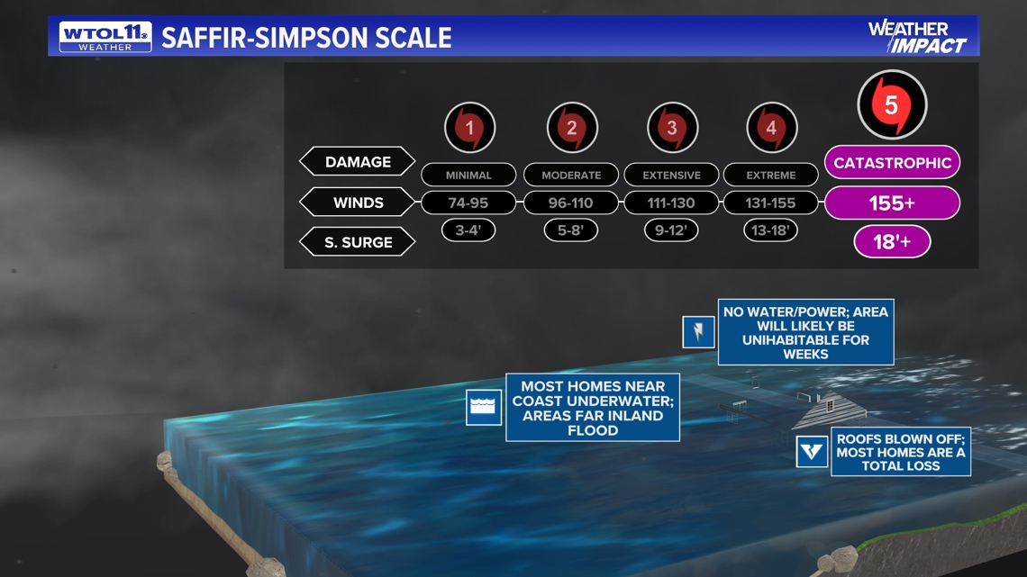
Saffir-Simpson Scale
Once a hurricane has reached the minimal strength to be known as a hurricane, at this point a system can still become stronger. How we can measure this is through a scale called the Saffir-Simpson Scale.
According to the National Hurricane Center (NHC) the scale – originally developed by wind engineer Herb Saffir and meteorologist Bob Simpson – has been an excellent tool for alerting the public about the possible impacts of various intensity hurricanes. The scale provides examples of the type of damage and impacts in the United States associated with winds of the indicated intensity.
The NWS states that the Saffir-Simpson Hurricane Wind Scale is a 1 to 5 rating based on a hurricane's sustained wind speed. This scale estimates potential property damage.
Hurricanes reaching Category 3 and higher are considered major hurricanes because of their potential for significant loss of life and damage.
This scale truly helps us prepare and determine what kind of a hurricane to expect no matter when or where it does arrive. This scale is pretty similar to the Enhanced-Fujita scale when it measures the severity of tornadoes.

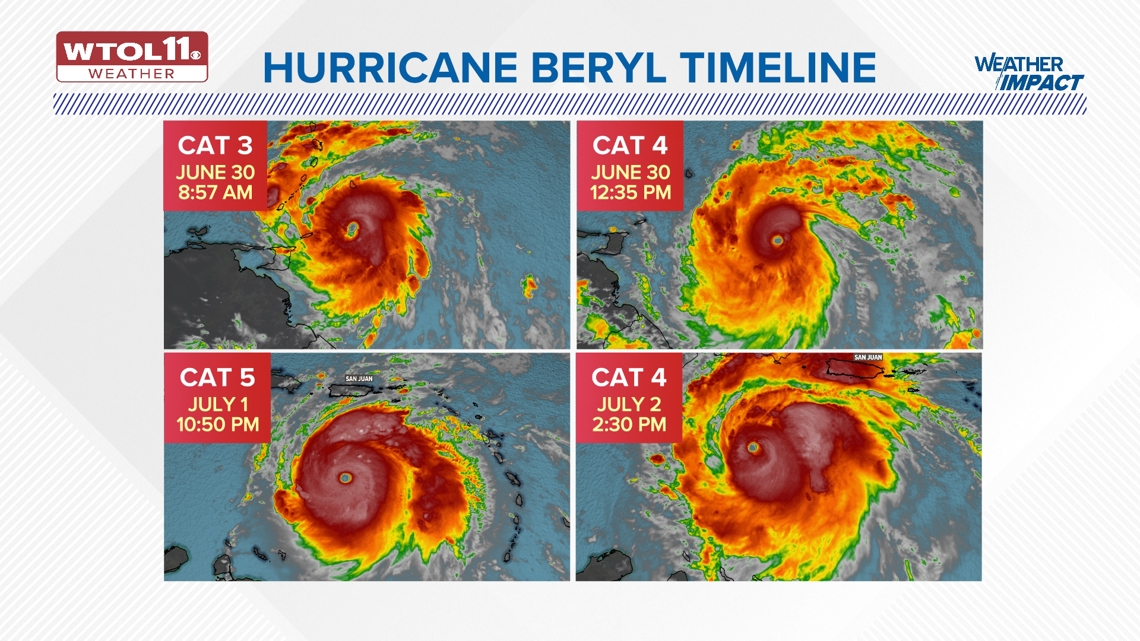
Hurricane Beryl
This week, we have seen our first hurricane of the hurricane season. Because of it being so early in the hurricane season, this specific hurricane has already broken several records.
Hurricane Beryl officially broke the record for being the earliest Category 5 hurricane ever recorded, shattering the old record set by Hurricane Emily in the summer of 2005. Hurricane Beryl reached Category 5 almost two weeks sooner than Hurricane Emily.
Due to the above-average ocean waters, Hurricane Beryl rapidly intensified from a tropical storm to a Category 5 hurricane in just a short 48 hours.
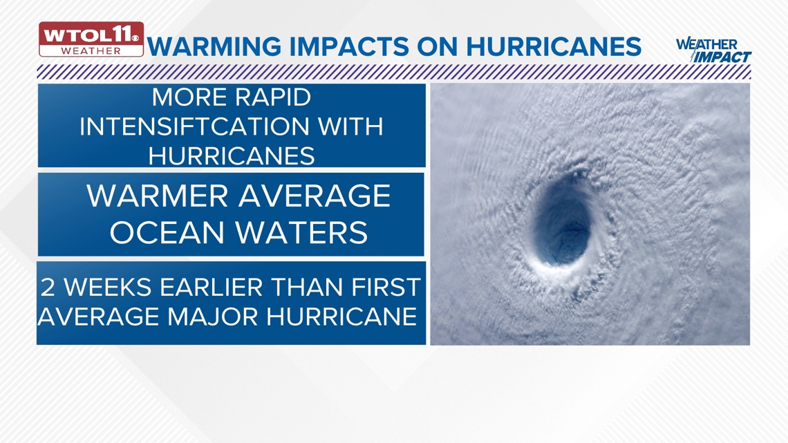
The technical definition of rapid intensification, according to NOAA, is when a hurricane’s winds increase by 35 mph or more in 24 hours or less. Multiple studies have shown that rapid intensification has become more common over the past three decades, pushing large storms to become even stronger.
Although this hurricane will not impact our area here in northwest Ohio, there have been hurricanes in the past that have brought remnants of storms into Ohio.

Warmer water impacts
When: Our oceans are warming at an alarming rate. As a result, if we continue to see warmer ocean waters, the intensity, frequency, and strength of storms will continue to grow as we go throughout each hurricane season. According to Weather Underground scientists, warmer ocean and surface temperatures are fueling changes that are leading to stronger and more dangerous storms. Because oceans soak up excess heat from the atmosphere, their temperatures are rising due to global warming. Studies have shown that hurricanes are staying stronger over land because climate change has pumped them full of warm moisture that serves as fuel, and their winds are pushing further inland. Sea levels along U.S. coastlines are expected to rise an average of 10 to 12 inches within the next 30 years, according to NOAA, pushing storm surge and flooding higher and making erosion worse.
Impact: As storms grow stronger and last longer the remnants of these storms could become more frequent, eventually impacting our area. Some may remember when Hurricane Ike made landfall in the U.S., and eventually made it into Ohio. Hurricane Ike brought 70 mph wind gusts and caused damage to several properties as the result of the post-tropical cyclone remnants of hurricane. Hurricane Sandy also brought 60 to 70 mph wind gusts to the lake shore areas of Lake Erie, which caused many areas of minor damage with debris and downed power lines. As stronger hurricanes become more frequent, the chance of remnants will become more common to northern states that are thousands of miles away from the southern coastal area.
Need: Warmer ocean waters will become more common throughout the year. Remember: as stronger hurricanes become more common, chances are that beach getaways and resorts, along with food supply, will be targeted by storms and hurricanes, putting our coastal areas in jeopardy. As waters warm, the life cycle of hurricanes could be longer impacting areas that are not usually impacted. As hurricanes continue to impact coastal areas, our beaches and marine life, will be severely impacted with extinction and coastal erosion.

MORE FROM WTOL 11 WEATHER IMPACT: