TOLEDO, Ohio — As the winter chill inches closer and we head further into October, winter’s snow and cold temperatures will become a common theme.
In the month of October in our area, it is still possible to get a wildcard of weather conditions, from warm and cold temperatures to severe weather, and even measurable snow like what we saw on Halloween last year.
Another common winter characteristic that is talked about during the later fall months is frost.
Frost arrives in the late night and stays through the early morning of those crisp fall days.
Of course, when frost does form on crops and plants, the weather must be cold. But have you ever wondered why and how frost forms?
In this week’s WTOL 11 Weather Impact, we are breaking down the science behind how frost forms and why it is so dangerous to our plants and crops during the harvest season. We will also take a look at different ways to prepare for the impacts of frost and freezing temperatures in northwest Ohio and southeast Michigan.
How does frost form?
Frost has the ability to damage sensitive plants, as well as cars and roofs. But to understand how to protect those things from the frost, we should know how frost works.
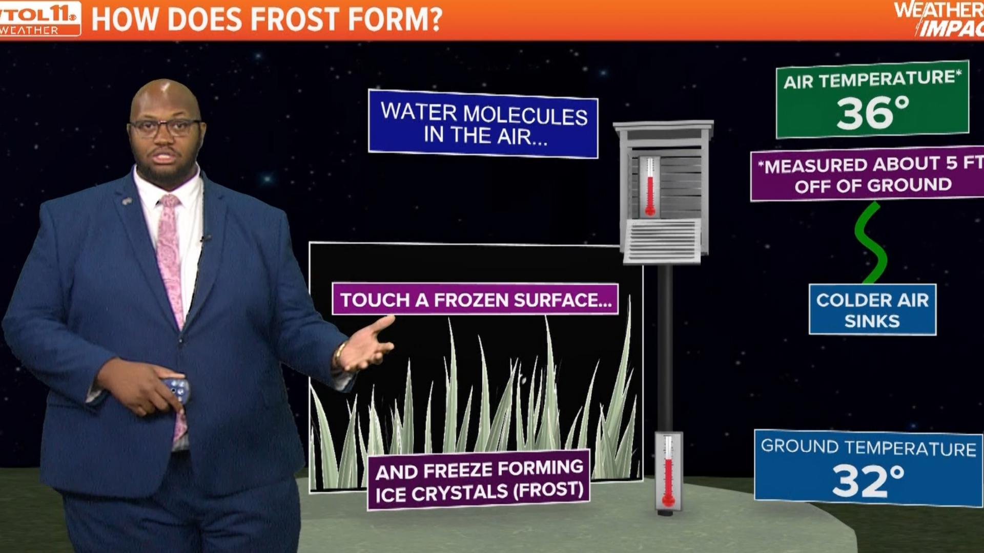
According to the National Weather Service, cold, heavy air remains closest to the ground, and allows surface temperatures to fall. Under the right conditions, especially clear, calm nights, the ground temperature may fall below the freezing point while the temperature measured in the air is still above freezing.
The reason we get colder temperatures near the ground is because of the more basic foundations of weather.
Cold air sinks and warm air rises, so when you already have a cold air temperature, that cold air is continuously forced down to sink into the surface making the surface of plants and cars significantly cold eventually forming what we call frost.
This is common in the autumn and winter, when nights are longer, which allows more time for cooling to occur.

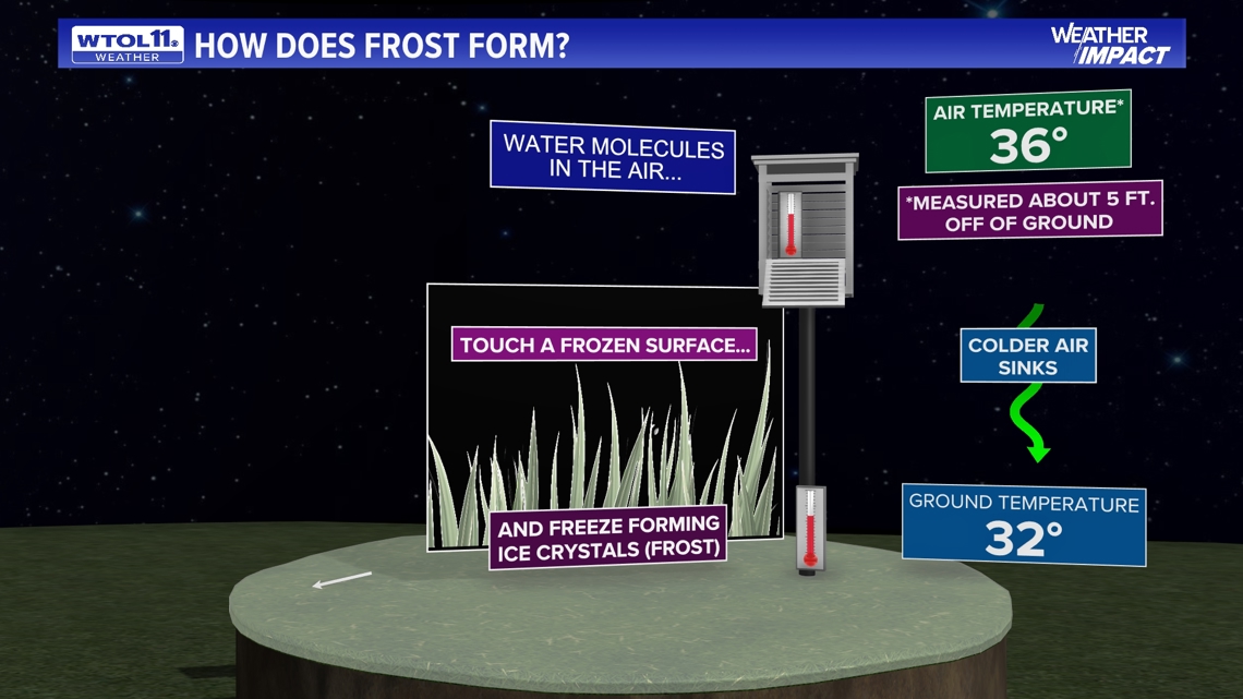
Frost itself is a covering of ice crystals on the surface of something - leaves, for example - when water vapor is deposited onto it and the temperature is cooler than 32 degrees.
That's why frost can occur when - technically - the air temperature has not gone below freezing. Frost can occur around temperatures as "warm" as 36 degrees. But as the ground is cooler for the aforementioned reasons, freezing or frosty temperatures will cause ice crystals to form.
The perfect recipe for frost
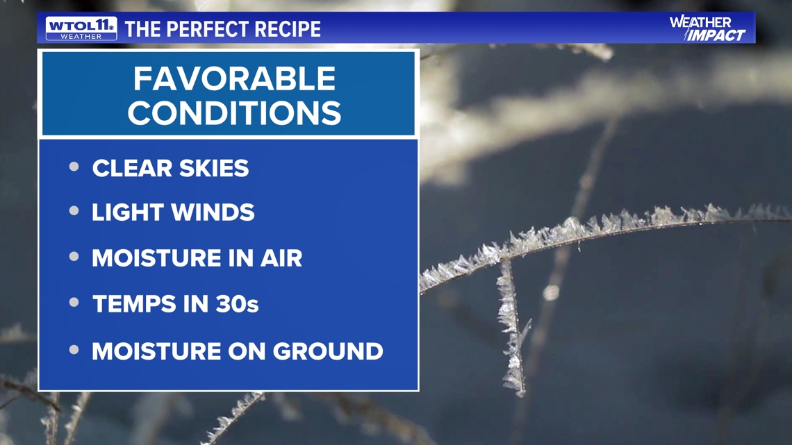
Just like any other weather phenomenon, it takes a process and a formula for something to happen.
There are quite a few components that need to come together for frost to not only form but also stick and stay on these plants which could be threatening to their survival.
The National Weather Service states clear skies are needed for frost to occur. This leads to radiational cooling, allowing the greatest amount of heat to exit into the atmosphere. Clouds, on the other hand, keep heat held in.
Calm winds are also a necessity. They prevent the stirring up of the atmosphere. Without strong winds, a thin layer of super-cooled temperatures can develop on the surface of a plant or object. These temperatures can be up to 10 degrees cooler than 4 to 5 feet above the surface, according to the NWS.
Naturally, cold temperatures also need to be present. When air with enough moisture in it is cooled to a lower temperature, the water will condense on surfaces. If it is cool enough, it will form ice crystals.

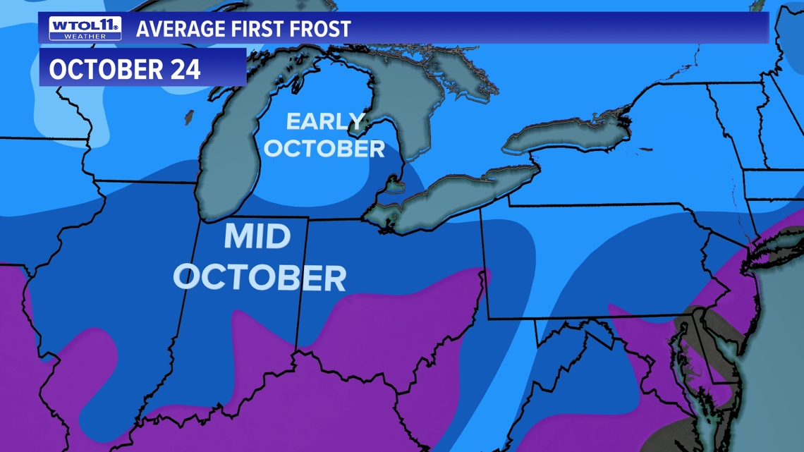
When to expect frost
The first frost marks some of the first signs that the weather is getting colder. During the fall, the average frost and freeze dates act to help farmers prepare and get the fall harvest done in time. Before the fall frost ruins the crops, they must work hard to get the most out of the season's plants.
Typically, in northwest Ohio and most of southeast Michigan, we see our first frost on average around Oct. 6, though it can (and has) appeared much later. As of Wednesday, Oct. 16, Toledo has not reached its first frost yet.
The first frost varies by region, with northern climates being colder earlier, and southern climates taking longer to reach those low temperatures.
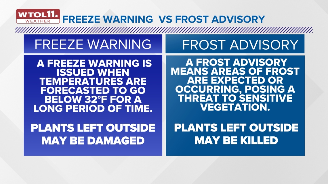
The National Weather Service issues frost advisories and freeze warnings to the public to inform them when these conditions could impact their homes, plants and crops.

Frost vs. freeze
In addition to frost, freeze also poses a threat to plants. While frost can happen at 36 degrees, a hard freeze does not occur until 32 degrees.
When we get into the colder temperatures such as temperatures dropping into the 30s, that is truly when we start to see hard freezes and plants being in jeopardy with how cold it is. When breaking down the different types of alerts that are being issued. The first one is typically a Frost Advisory.
A frost advisory occurs when frost is expected, which poses a threat to sensitive vegetation. As stated before, frost can occur when temperatures are around 36 degrees.
A freeze watch is different: it indicates there is a potential for significant, widespread freezing temperatures withing the next 24 to 36 hours. But they aren't issued through the winter; freeze watches and warnings are issued in the fall until the end of the growing season. When the growing season returns in the spring, but cold temperatures are still possible, the advisories are issued again.
According to the National Weather Service, a Frost Advisory means areas of frost are expected or occurring, posing a threat to sensitive vegetation. A Freeze Watch Means Be Prepared. A Freeze Watch is issued when there is a potential for significant, widespread freezing temperatures within the next 24-36 hours.
A Freeze Warning is issued when temperatures are forecasted to go below 32 degrees for a long period. This temperature threshold kills some types of commercial crops and residential plants, while temperatures below 28 degrees for an extended period can kill most types of commercial crops and residential plants.

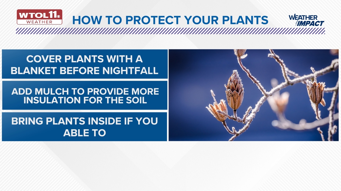
Overnight warming impacts and protecting your plants
Over the years, we have seen frost and freeze dates pushed back significantly due to our warming climate.
In fact, according to Climate Central, throughout Toledo since 1970 we have seen 31 fewer nights where we see temperatures at 32 degrees or lower, and global warming is all to blame for this happening.
Although frost has become less frequent over the years can be a good thing for the growing season, when we talk about winter becoming later and shorter this is certainly one of the signs of winter losing its chill.

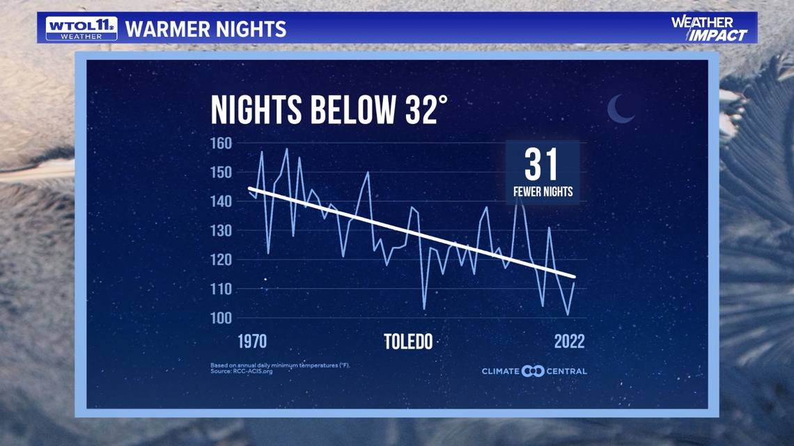
Through the fall nights and days, we have warmed an average of 4 degrees since 1970, so all things that gorgeous fall brings could be heavily impacted especially fall foliage, and the transition from fall to winter.
Protecting your plants and crops from frost will save money and help all your beautiful greenery stay alive more into the fall season for presentation and harvest.
According to Iowa State University Yard and Garden, freezing temperatures won't harm dormant plants. They can damage new spring growth, though, like flower buds. Buds are vulnerable to cold temperatures.
The extent of damage will be determined by the plant species, stage of plant development, and temperature.