
TOLEDO, Ohio — When active and severe weather occurs, it's important to know the difference between a watch versus a warning.
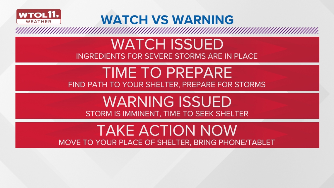
A watch means the ingredients for the storm is there. However, the timing and location is still uncertain. The storm is being "watched" by forecasters who are monitoring its direction and strength. For example, moisture, instability, lift and wind shear may indicate to meteorologists that severe weather could happen - but it hasn't happened yet.
A warning means dangerous weather is occurring and it could be life threatening. This could mean taking shelter in severe weather, or staying inside and hydrating.
A good way to differentiate the two is think of a watch as the ingredients are there and the warning is when the item is there. Sometimes this is articulated using food as an example. If you have flour, milk, butter and eggs, you have the ingredients for cupcakes, but no cupcakes yet exist. Forecasters are watching to see if the ingredients will make "cupcakes".
If the ingredients come together to create the item, then its time to take action, like seeking shelter in the event of a tornado or severe thunderstorm. (If they are actual cupcakes, though, you can just go ahead and eat them.)


Watches, warnings and advisories are issued for a variety of weather events. Though they're often issued for severe weather, they aren't limited to just storms. Here are some of the types of watches and warnings issued by the National Weather Service.
- Tornado Warning: A tornado has been detected by radar or spotters. Take shelter immediately.
- Tornado Watch: Prepare for severe thunderstorms with large hail, damaging winds and possible tornadoes. Timing and location is uncertain.
- Severe Thunderstorm Warning: A severe thunderstorm is occurring with winds 58 mph+ and/or hail 1 inch in diameter. Take shelter immediately.
- Severe Thunderstorm Watch: Prepare for severe thunderstorms with large hail, damaging winds and possible tornadoes. Timing and location is uncertain.
- Extreme Wind Warning: Winds over 115 mph associated with non-convective, downslope, derecho, or sustained hurricane winds within one hour is expected.
- High Wind Warning: Sustained winds of 40mph+ for an hour or wind gusts over 58mph are expected.
- High Wind Watch: Sustained winds of 40mph+ for an hour or wind gusts over 58mph are possible within the next 24 to 48 hours.
- Wind Advisory: Sustained winds of 30-39 mph for an hour+ or wind gusts of 46-57 mph for any duration are expected.
- Dense Fog Advisory: Reduced visibility of 1/4 mile or less over a large area for 3 hours+ is expected.
- Winter Storm Warning: 6 inches+ of snow and/or 1/4 inch+ of ice accumulation is expected.
- Winter Storm Watch: A combination of 6 inches+ of snow or 1/4 inch of ice accumulation is possible within 48 hours.
- Blizzard Warning: Snow reduces visibility of 1/4 mile or less for 3 hours+ and winds of 35 mph+.
- Ice Storm Warning: ¼ inch+ of ice accumulation expected resulting in downed trees, power outages and dangerous travel.
- Winter Weather Advisory: 4 inches of snow or 1/4 inch of ice is expected.
- Freeze Warning: Temperatures at or below 32 degrees are expected. A Freeze Warning is issued at the beginning and end of growing season.
- Freeze Watch: Temperatures at or below 32 degrees are possible in the next 18-24 hours. A Freeze Watch is issued at the beginning and end of growing season.
- Frost Advisory: Low temperatures between 32-36 degrees with clear skies and calm winds. A Frost Advisory is issued at the beginning and end of growing season.
- Wind Chill Warning: Wind chills of -25 degrees or lower with wind speeds of 5 mph for 3 hours+.
- Wind Chill Watch: Wind chills of -25 degrees or lower with wind speeds of 5 mph for 3 hours+ within the next 18 to 48 hours.
- Wind Chill Advisory: Wind chills of -10 to -25 degrees for 3 hours+.
- Excessive Heat Warning: Heat index of 105 degrees+.
- Excessive Heat Watch: The potential for the heat index of 105 degrees or more within the next 24 to 48 hours.
- Heat Advisory: Heat index of 100-104 degrees within the next 12 to 24 hours.
- Flood Warning: Flooding is imminent or occurring.
- Flood Watch: Flooding is possible.
- Small Craft Advisory: Winds of 20 knots+ or waves 4 feet+.
- Gale Warning: Winds of 34-47 knots for 2 hours+.

The history of watches and warnings
To learn about the origins of weather alerts, we must go back more than 70 years to the first-ever tornado forecast.
According to the National Weather Service, a tornado developed on March 20, 1948 near the Tinker Airfield and moved northeast across the Air Force Base in Oklahoma. The destructive storm damaged and destroyed airplanes and caused injuries. Meteorologists were able to accurately predict a second tornado threat just five days later: the first-ever tornado forecast.
County-based warnings to storm-based warnings
Throughout the following years, county-based warnings were issued for certain areas that could see dangerous weather. Along with these county-based warnings, tornado sirens and radio were heavily relied upon to put out these warnings before television and internet were invented to do such things.
For many years, these watches and warnings were issued for entire counties. However, as technology improved, the National Weather Service said forecasters were later able to issue the alerts for only the specific portions of counties affected by the severe weather.
Beginning Oct. 1, 2007 the National Weather Service began to specify areas within a county and refer to commonly known landmarks, such as highways or rivers, when issuing the alert. This marked the move from county-based to storm-based warnings. They are more accurate and focus on the areas actually impacted by the storm, not just geopolitical boundaries.
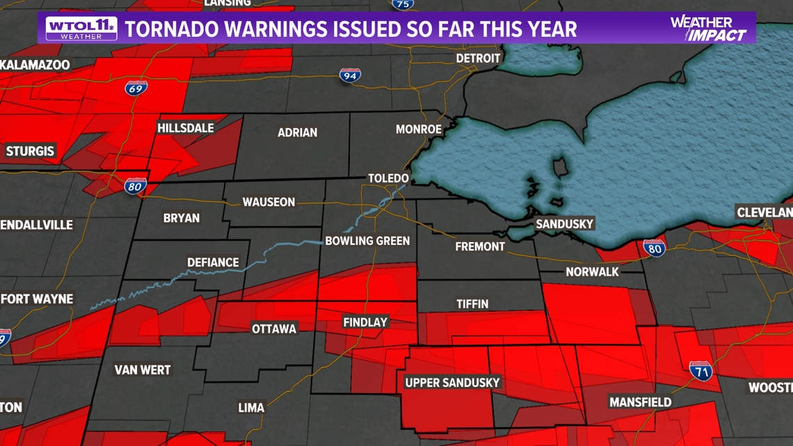
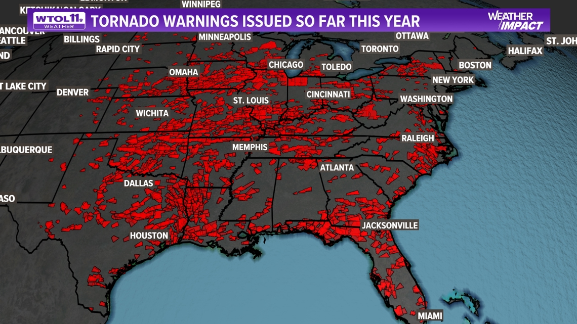
Watches and warnings today continue to save lives as they inform you, your family and people across the country about severe weather events. Check out the maps below to see where tornado warnings were issued in our region this year, as well as in the United States.

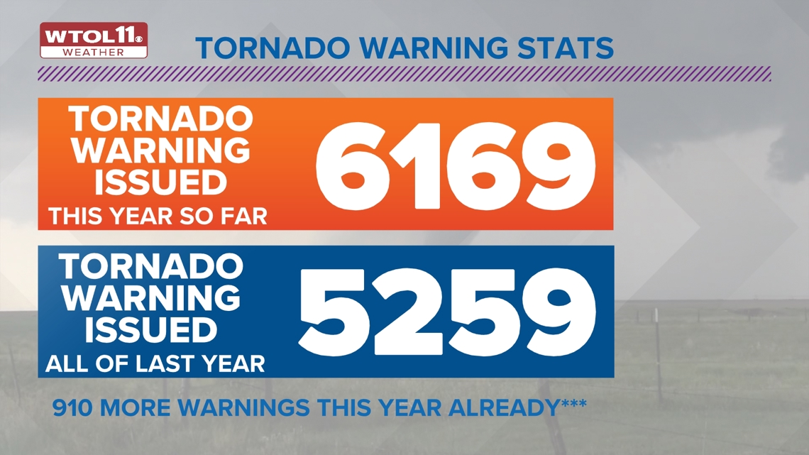
As of this week, the National Weather Service has issued over 6,000 tornado warnings across all 50 states. Now keep in mind they issued 5,259 tornado warnings last year, so we have already passed warnings issued from last year by almost a thousand additional warnings.

To ease worry and stress, the National Weather Service, and local meteorologists are working around the clock to keep you safe and informed about any weather that may impact your day or week. Although weather and weather disasters will continue to happen for many years to come, staying alert, and aware of what is going on week to week can be the difference between saving lives, and unprepared catastrophic events.

With four months still left in the year, the year-to-date for tornado reports sits at 1,495, and we have already broken the record for confirmed tornadoes in the state of Ohio with 70 at this point. The lesson to learn from this is to always stay vigilant throughout all four seasons when it comes to weather.
WATCH MORE FROM WTOL 11 WEATHER IMPACT