
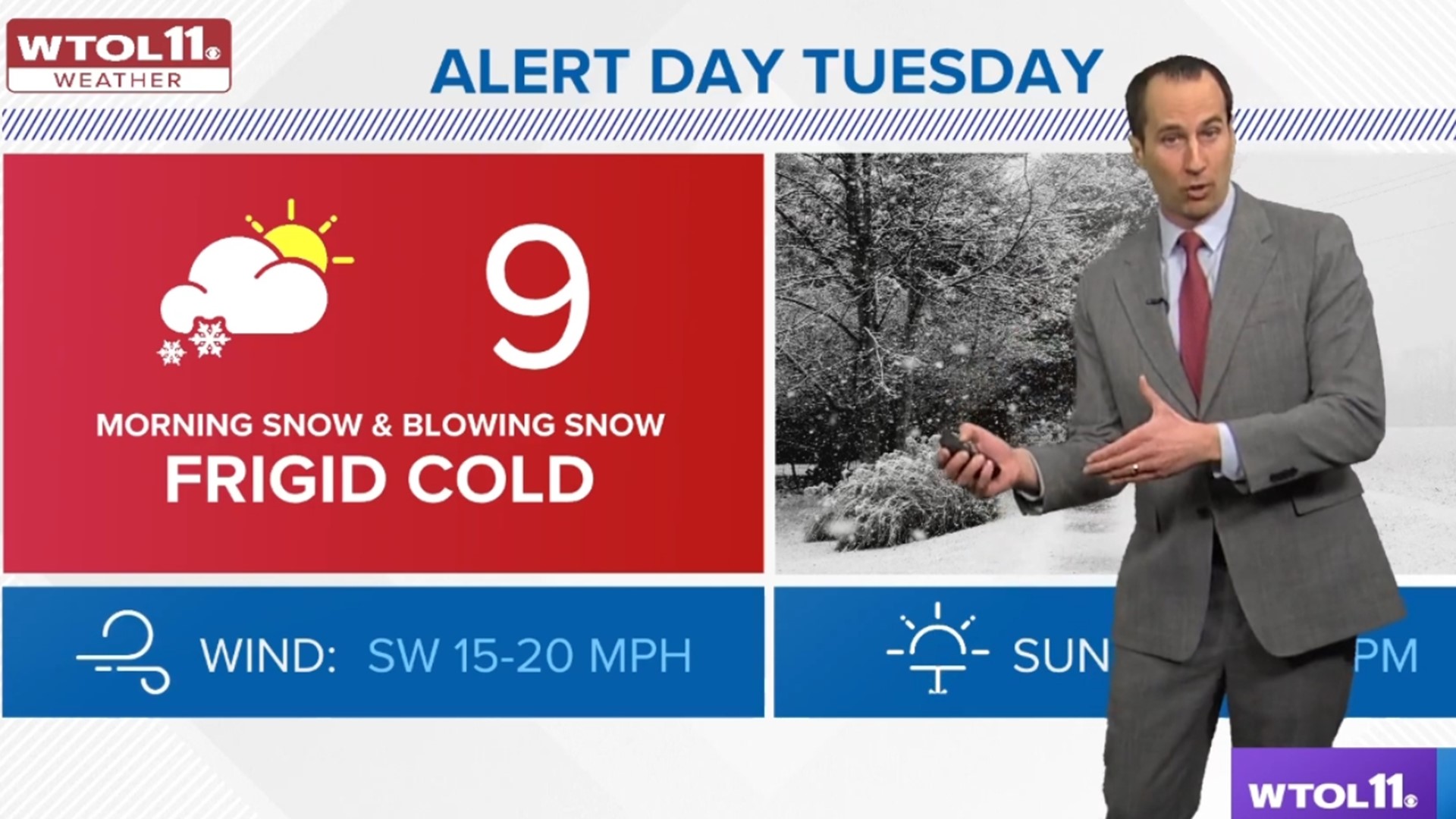
TOLEDO, Ohio — WTOL 11's weather team has issued an ALERT DAY for more wintry weather predicted to hit our region Tuesday.
A combination of bitterly cold temperatures, another round of snow early in the day and gusty winds will deliver extreme winter conditions Tuesday.
Several local school districts, including Toledo Public Schools and Washington Local Schools, announced Monday afternoon that classes are canceled for Tuesday because of the predicted extreme winter weather.
CHECK THE LIST: School delays and closings
Here's what you need to know about the three elements of Tuesday's weather:
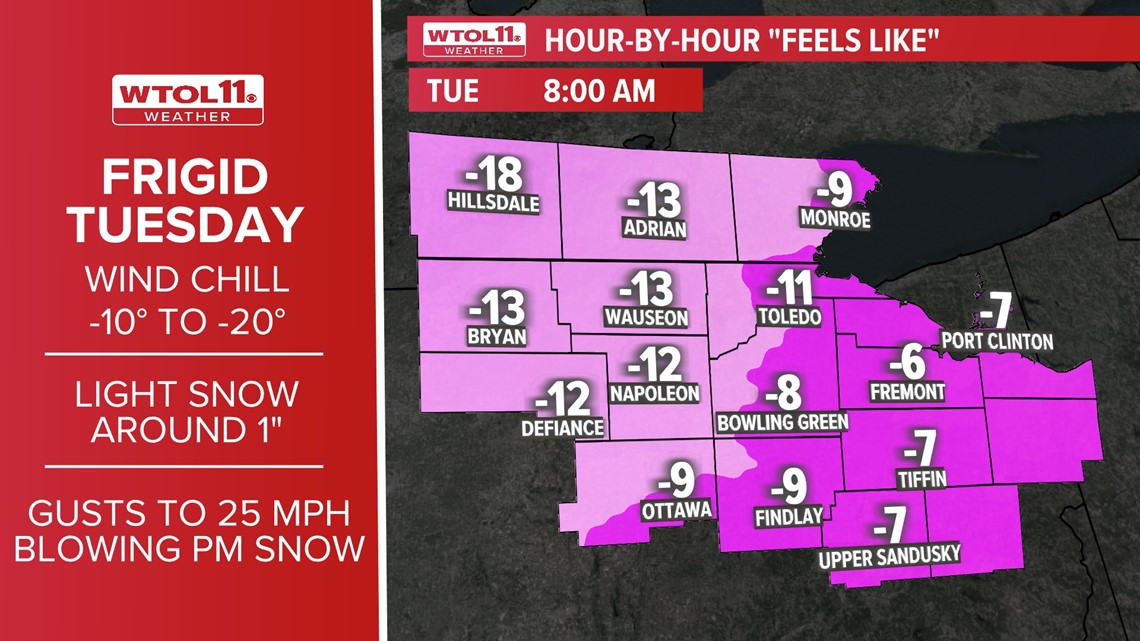
Bitter cold:
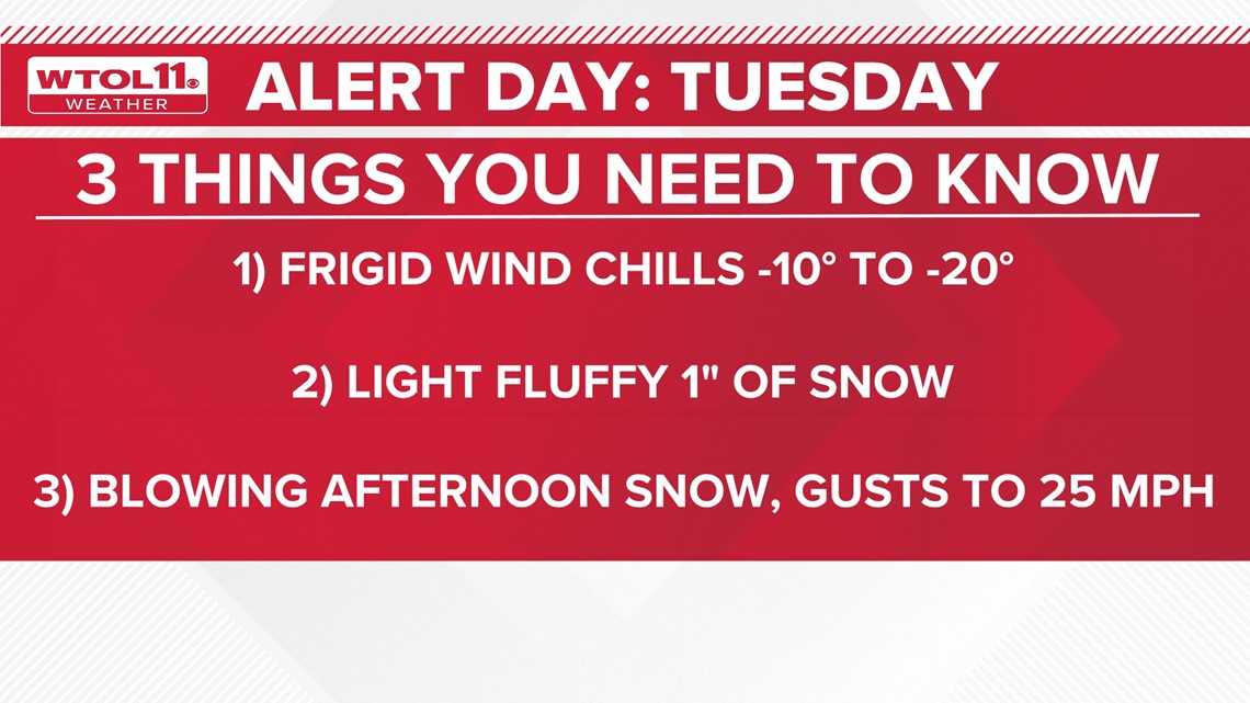
Bitter cold wind chills will be expected to continue across the areas through Tuesday. The coldest part of the day will be early in the morning with wind chills of -10 to -20 degrees through mid-morning. Wind chill advisories are in effect for parts of the area especially along and west of I-75.
This type of cold can before especially dangerous with the risk of frostbite in 30 minutes or less during times of prolonged exposure. Wind chills will remain below zero the entire day and again for the night ahead.

Snow:
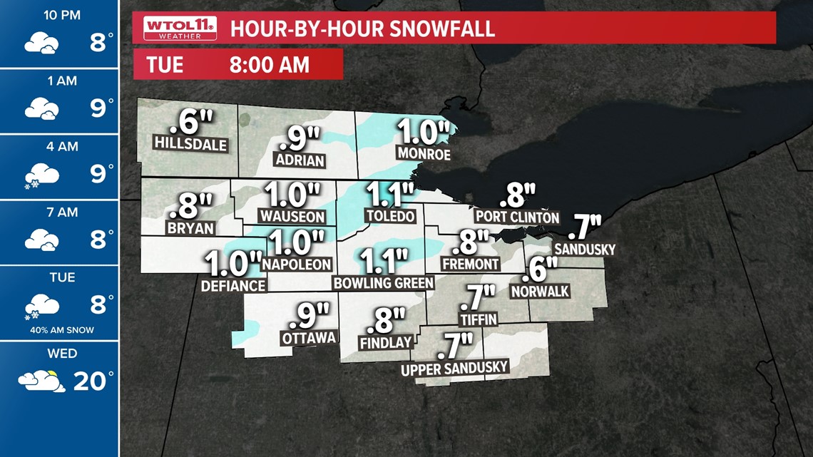
Light and fluffy snowfall is expected. This light snow will arrive overnight Monday and into early Tuesday morning. For most areas, this is 1 inch or less of accumulation.
However, the timing of this snow arriving before daybreak will create icy and slippery roads for the morning commute and at the bus stop.
With the extreme cold and snow, many school districts are choosing to delay or cancel school. Roadways may remain slippery and icy much of the day as road salt is highly ineffective during such cold conditions and plowing will do little to clear frozen and icy roads.

Gusty winds and blowing snow:
Blowing snow will increase into the afternoon. There will be no additional snow accumulations during the afternoon hours, but increasing winds will cause the very light and fluffy snow to easily blow and drift back onto roadways. This may result in some areas of poorer visibility and icy and snow-covered roads. Be especially cautious in rural areas as the winds will tend to blow and drift the snow more easily in these locations.
Gusty winds will allow for blowing and drifting of snow through the afternoon Tuesday. Areas of poor and hazardous travel will be possible because of the blowing snow.
For full details of Tuesday's ALERT DAY weather and the entire WTOL 11 forecast, visit our WTOL 11 weather page.

More on WTOL:
Get a fresh start to your morning and wrap up your day with the latest news and your WTOL11 Weather forecast delivered right to your inbox! WTOL's Your Morning Blast and Your Evening Blast deliver stories from northwest Ohio, southeast Michigan and beyond to keep you informed. Click here to get on the list!
Stay up to date on what's happening in your community with a 24/7 live stream and on-demand content from WTOL 11+.
Our free WTOL 11+ apps are available on Roku and Firetv.
WTOL 11+ features the latest breaking news and weather, plus daily talk shows, coverage of your favorite sports teams from Locked On, fact-checking from VERIFY and the latest trending stories from Daily Blast Live.
Looking for the lowest current local gas prices? Check out the WTOL 11 gas price tracker, powered by Gas Buddy, here.