
TOLEDO, Ohio — After a relatively cool and dry July, a similar weather pattern is unfolding into early August, providing below-average temperatures and rainfall to the region. With summer already two thirds in the books, you may be wondering if the WTOL 11 Weather Team is expecting any major heat or widespread rain in the forecast. Meteorologist John Burchfield looks ahead to the rest of August in this week's Climate Friday Newsletter.
When you think of the "dog days of summer", August weather may come to mind. August is statistically the second hottest month of the year with an average high temperature slightly over 84 degrees. While July ranks as the hottest month of the calendar year, August surpasses June for the second spot.
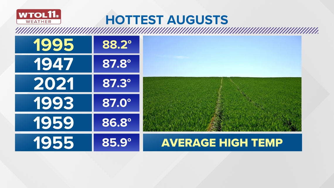
Sometimes August brings the hottest weather of the summer and often delivers stifling humidity. 1995 was the hottest August on record with an average high temperature of 88.2 degrees. 1947 ranks as the second hottest with an average high just shy of 88 degrees. In recent memory, 2021 ranks as the third hottest August on record with an average high of 87.3.

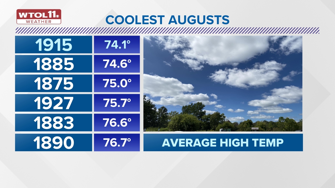
While August often brings summer heat, it sometimes features a preview of fall. August is notorious for producing big temperature swings ranging from extreme heat to chilly weather. 1915 ranks as the coolest August on record with an average high temperature of just 74.1 degrees. Of the six coolest Augusts in Toledo's recorded history, four occurred in the late 19th century. The other two happened before 1930.
RELATED: When is the first day of fall?

Observational data in Toledo points toward an overall warming trend during the month of August, in part due to climate change. These unusually cool Augusts are on average becoming a thing of the past. You will feel below-average temperatures for much of the 10-day forecast; read on as Meteorologist John Burchfield looks ahead to the rest of the month.
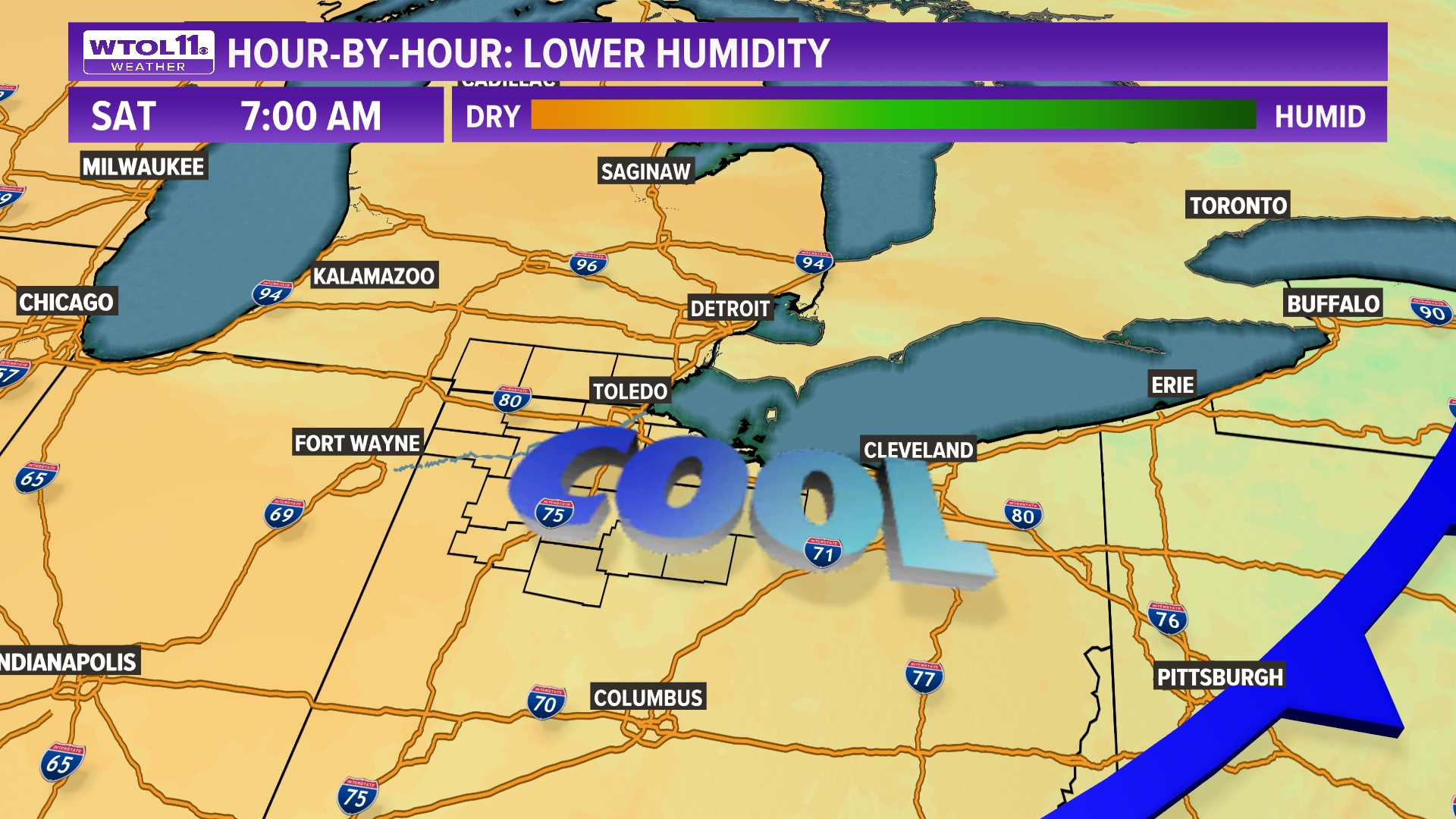
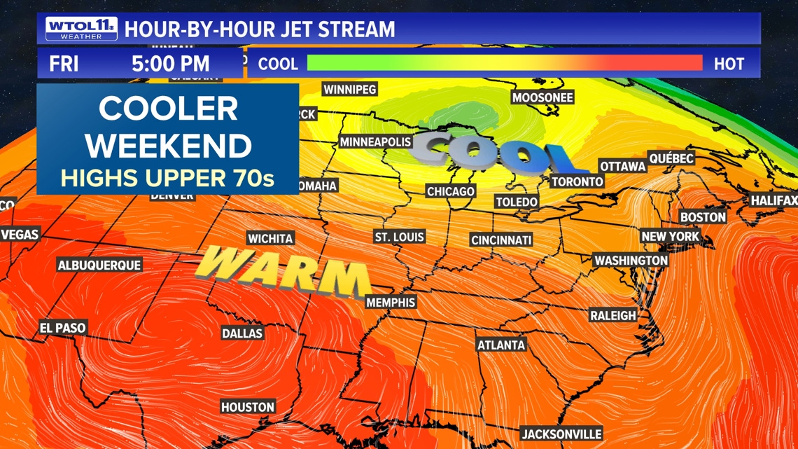
After a relatively cool July that ended up 2.4 degrees below-average, August is starting off on a cooler note. A strong cold front will lower both temperatures and humidity this weekend, providing a little preview of fall. High temperatures will drop down to the upper-70s and overnight lows will fall to the 50s.


This weekend will also bring reprieve from the humidity with dew points in the 50s. You'll feel a sharply cooler northwest breeze in the wake of the cold front. Is this a sign of what's to come for the rest of the month?
For much of the Great Lakes and New England, mid-August will bring below-average temperatures largely in the upper-70s to near 80 degrees. Our normal high is still in the mid-80s, so these 70s are considered seasonably cool for the middle of August.

By the end of August, average highs drop back to 82 degrees, a sign that fall is right around the corner. The weather pattern may shift back to a warmer trend with temperatures slightly above-average. Even with a late month warmup, the WTOL 11 Weather Team does not see any major heat on the horizon.
FULL FORECAST: Breezy Friday with highs slowly climbing near 80 degrees; cooler weekend ahead | WTOL 11 Weather
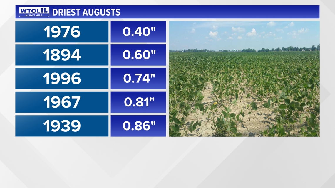
Additionally, August looks to turn sharply drier without any widespread rainfall for over a week. After a July that only brought 2.81 inches of rain, 0.46 inches below average, August started off with downpours and thunderstorms that left many areas looking forward to drying out. This week will bring no shortage of sunshine, and many gardeners and farmers will be in need of some rain by the end of next week.

Just like with temperatures, rainfall can vary greatly during the month of August. The wettest August on record occurred in 1965, when 8.47 inches of rain inundated northwest Ohio. The driest August on record was in 1976, which brought just 0.40 inches of rainfall. August can bring both flooding and drought, and sometimes even both in the same month. This August is trending drier into the middle to latter half of the month.
Stay tuned to the WTOL 11 Weather Team for the latest forecast and subscribe to the Climate Friday Newsletter for updates as we finish off the summer season.
MORE EPISODES OF CLIMATE FRIDAY